Pattaya Travel Guide - Understand
History
Pattaya's name was originally "Thap Phraya", meaning Army of
the Phraya - commemorating the surrender of Nai Klom's army to
that of Phraya Tak (later King Taksin the Great), without a fight.
Thap Phraya became Phatthaya (the name of the north-easterly wind
at the beginning of the rainy season), and then Phatthaya (the
true phonetic spelling).
The Vietnam War and its warriors made Pattaya a well-known recreational
centre, especially among American GI’s. From its beginning in
1959 with a small private bungalow where American officers on
leave took turn to come and rest, this sleepy village by the sea
has grown and changed dramatically into one of the world’s tourism
hot spots. The opening of the new Suvarnabhumi Airport
(located to the east of Bangkok, alongside the expressway to Pattaya)
has made visiting easier than ever.
Pattaya is popular not only as a beach resort and for its entertainment,
nightlife and shopping, but also for the broad selection of pastimes
it caters for, from golf and horseback riding to bungee
jumping, karting and shooting - not to mention a wide variety
of watersports such as scuba diving, jet-skiing,
sailing, water skiing, windsurfing and kitesurfing, and a whole
lot more. Pattaya is also very popular as a conference, convention
and seminar venue, and the grapevine hosts rumours of future developments
of varying degrees of plausibility, such as a horse racing track,
casinos, and a tram system.
The Tourist Authority of Thailand (TAT) [1]
Information Office is just outside the centre, exactly 1 km south
of the junction of Second Road and South Pattaya Road - proceed
along Pratamnak Road, continue straight up the hill, and where
the road bears sharp right part way up, turn sharp left into the
small side-soi. Worth a visit if you're in Pattaya for an extended
period and want to browse for fresh ideas for new things to do/see.
Open daily 8:30AM-4:30PM, tel. +66-38428750 / 8990 / 7667
or use the TAT freephone number: dial 1672 or e-mail: tatchon@tat.or.th
Orientation

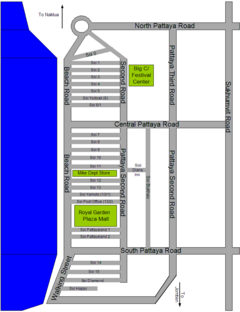
 Map of major roads in Pattaya (not to scale)
Pattaya's downtown area is easy to get around.
Running north-south, a few hundred metres apart, are Beach
Road (Thanon Hat Pattaya, sometimes also referred to as First
Road) which borders the main beach (Hat Pattaya), Pattaya Second
Road and Pattaya Third Road (with the smaller but busy
Soi Buakhao in between), and the main Sukhumvit Road
coastal highway. Beach Road is one-way (southbound), likewise
Second Road (northbound).
These are connected by the three major east-west aligned roads:
North Pattaya Road (Thanon Pattaya Nua), Central Pattaya
Road (Thanon Pattaya Klang) and South Pattaya Road
(Thanon Pattaya Tai). North Pattaya Road is a dual carriageway
and carries the highest volume of traffic to and from Sukhumvit
Road.
Also connecting Beach Road and Second Road are a large number
of smaller streets or "sois". The main sois are numbered from
1 to 16, from north to south. Sois 1-6 are between North Pattaya
Road and Central Pattaya Road; sois 7-13 are between Central Pattaya
Road and South Pattaya Road (including the "Pattayaland" sois,
immediately north of South Pattaya Road); sois 14-16 are south
of South Pattaya Road. Most of these east-west sois are (in theory
at least) one-way.
Beach Road, Second Road, and North Pattaya Road (plus Naklua
Road to the north) all meet at the Dolphin Roundabout landmark.
Heavy traffic and frequent accidents here have resulted in a semi-permanent
diversion being set up which, at peak times, prevents vehicles
(except motorcycles) from continuing around this roundabout any
further than the North Pattaya Road exit, pending the installation
of traffic lights some time in 2006.
Second Road south of South Pattaya Road becomes Pratamnak Road,
which shares a junction with both the southern end of Third Road
and the northern end of the main road to Jomtien, Tappraya Road.
Beach Road south of South Pattaya Road is closed to vehicles
in the evenings (currently 18:00-02:00) and is called Walking
Street; it's the main tourist area, both for nightlife and
shopping. Other major tourism areas include the section of Second
Road between sois 1-4, and the sois immediately north of South
Pattaya Road.
At the southern end of Walking Street is the New Pier, usually
called Bali Hai Pier (sometimes "Pattaya Pier" or "South
Pier"). The Old Pier, close to the junction of Beach Road and
South Pattaya Road, is still shown on most maps but was dismantled
and removed at the beginning of 2006.
|


